Dune ha partecipato a due fiere finanziate da Lazio Innova tramite il VOUCHER INTERNAZIONALIZZAZIONE PMI, Atto di Impegno – Domanda prot. n. A0655-2023-080172 – PR FESR Lazio 2021- 2027 – Avviso pubblico – di cui alla Det. N. G13698 del 18/10/2023
Le due fiere a cui abbiamo partecipate si sono tenute a Parigi e Londra nei mesi di Novembre e Dicembre 2024.
Expoprotection – Parigi dal 05/11/2024 al 07/11/2024. Alla Fiera abbiamo presentato il nostro sistema di localizzazione indoor ARIANNA, distribuito volantini relativi al prodotto ed eseguito prove dimostrative dello stesso. I visitatori sono stati numerosi e sono da annoverare fra gli utilizzatori finali del sistema ARIANNA e potenziali distributori dello stesso presso enti o stati diversi dalla Francia. Tutti i visitatori sono stati localizzati mediante i loro riferimenti e verranno contattati più volte con mail specifiche o telefonate. Fra gli altri, siamo stati visitati da alcuni rappresentanti del CERN che hanno manifestato un interesse specifico per il sistema.
Anticipate Londra, FIREX – Londra dal 02/12/2024 al 04/12/2024. Anche in questa Fiera abbiamo presentato il nostro sistema di localizzazione indoor ARIANNA, distribuito volantini relativi al prodotto ed eseguito prove dimostrative dello stesso. Si sono presentati numerosi visitatori che hanno chiesto dettagliate informazioni sul prodotto. Riteniamo che in futuro sarà possibile sfruttare le conoscenze acquisite durante l’esposizione per poter vendere i nostri prodotti sia sul mercato inglese che su quello internazionale, fra i vari visitatori si sono presentate anche persone provenienti dagli Stati Uniti.

INTERNATIONALIZATION PROJECT
Dune participated in two fairs financed by Lazio Innova through the VOUCHER PMI INTERNATIONALIZATION, Act of Commitment – Application prot. n. A0655-2023-080172 – PR FESR Lazio 2021- 2027 – Public notice referred to the Determination N. G13698 of October 18th 2023
The two fairs we attended were held in Paris and London in November and December 2024.
Expoprotection – Paris from 05/11/2024 to 07/11/2024. At the fair we presented our indoor localization system ARIANNA, distributed leaflets related to the product and performed demonstration tests of the same. The visitors were a great number and among them the end users of the ARIANNA system and potential distributors of the system to Institutions or Countries other than France. All visitors have been located by their references and will be contacted several times with specific e-mails or phone calls. Among others, we were visited by representatives of CERN who have expressed a specific interest in the system.
Anticipate London, FIREX – London from 02/12/2024 to 04/12/2024. Also in this fair we presented our indoor localization system ARIANNA, distributed leaflets related to the product and performed demonstration tests of the same. Many visitors came to visit us and asked for detailed information on the product. We believe that in the future it will be possible to use the knowledge acquired during the exhibition to sell our products both on the British and international markets. Visitors from the USA also attended.
SEAVIEW
Project financed by Sicily Region is related to the development of an integrated system consisting of a ROV and a payload. Dune will collaborate with other companies (Tecnav, CNR and University of Palermo) for the development of the payload that creates an integrated vision of an acoustic and optical type. The acoustic system consists of two observation groups each one made by three receiving antennas. The elementary acoustic antenna will be constructed in such a way as to reduce to a minimum the number of electrical connections in respect of to the process electronics.
Dune will take care of the development of the acoustic data transmission / reception system and the beamformer management in order to produce the acoustic image of the environment. This image will be sent to the Man Machine Interface (MMI) section for the purpose of immediate visualization for the user and with the intent of making a fusion between this image and that coming from the optical sensor.
HORTA
Project financed by Lazio Innova for the study and construction of CUBESAT 6U class satellites, designed to embed payloads for earth observation and remote sensing. The proposed payload is a passive GNSS-R reflectometer for the analysis of the soil condition, in particular of the humidity and biomass characteristics, flanked by a high-bit Banda Ka transmitter.
HORTA also proposes to study and implement a reception and processing center of data sent to the ground by CUBESAT, in order to offer a turnkey service to users, whether public or private. Dune deals with the development (HW and SW) of the payload as well as the communication systems in the UHF and S bands for the transmission of telemetry and payload data.

- Description of the Project
The HORTA initiative, a SATELLITE MISSION for PRECISION FARMING applications, is aimed at the study and implementation of EQM and PFM of innovative solutions for CUBESAT 6U CLASS SATELLITE systems and subsystems, intended to embark payloads for EARTH OBSERVATION and REMOTE SENSING. The proposed payload is a passive GNSS-R reflectometer for the analysis of the state of the soil, in particular of the characteristics of moisture and biomass, whose data will be sent to the ground via a high bit-rate transmitter in Ka Band. The HORTA project also aims at the study and construction of a RECEPTION and PROCESSING CENTER for the data sent ashore by CUBESAT, in order to offer a turn-key service to users, whether public or private. The project addresses EARTH OBSERVATION TOPICS, in particular “land use & land surface change applications”, in response to the “SPACE” SOCIAL CHALLENGE, considered a priority by the main stakeholders for the “AEROSPACE” Specialization Area.
- Purpose
Creation of a scientific / industrial chain located in the Lazio Region for the construction of advanced nano-satellites and supply of services related in particular to the agricultural and environmental sector. Training of new professionals for the future competitive repositioning of local companies carried out in collaboration between partner SMEs and the University of Tuscia. Creation of a Center for the Reception and Processing of data sent by the Satellite within the facilities of the University of Tuscia.
- Results
Implementation of a satellite mission for precision farming: analysis of the state of the soil, humidity and bio-mass, using the passive GNSS-R reflectometer.
- Financial support received
Co-financing € 876,730.27

CLINAIR

CLINAIR TECH PROJECT – CLEAN INDOOR AIR TECHNOLOGIES
AVVISO PUBBLICO «LIFE2020» , DET. N. G08726 DEL 29 LUGLIO 2016
POR FESR LAZIO 2014-2020 – PROGETTI INTEGRATI
DOMANDA PROT. NR. A0112-2016-13380 DEL 13/12/2016
CUP NR. F87H18000350007
The CLINAIR-Tech project intends to develop a building automation system based on patented methodology and algorithm to improve indoor air quality (IAQ) with preventive management of the cleaning processes of HVAC-conditioning systems. With an innovative data acquisition device (fine powders, humidity, temperature), and advanced polymer foam filter and a CLINAIR WEB platform, it will improve the IAQ by assessing and preventing non-invasive cleaning of plant filters and pipelines HVAC.
SENSI Project – Laser integrated System
M.I.U.R. – MURST, Mediterranean Environment Research Program The system has integrated an incoherent laser range finder with a passive stereo optical system based on image processing from visible spectrum cameras.
DUNE has designed the system architecture as well the laser data acquisition, development of the stereo-vision algorithms and of the visualization SW.
The system has been developed on a cluster of 8 DSP Hammerhead.
TOMPACO Project – Marine Temperature Control
M.I.U.R. – MURST, Mediterranean Environment Research Program The system has been designed to measure the marine temperature fields by passive acoustic tomography.
DUNE has focused its activities in project coordination, acoustic propagation model study and synthesis and optimization of the tomographic algorithms.
The company has also leaded the validation campaign at the Atlantic Ocean.
ATOMOS
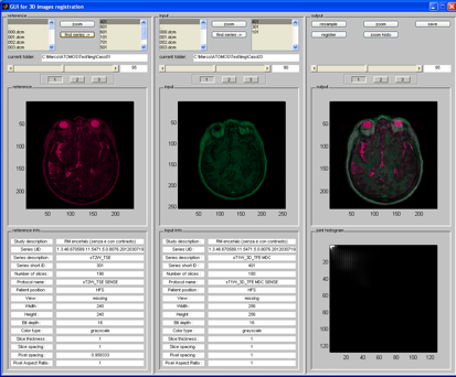
The research project funded by Lazio Innova deals with the problem of analysis, implementation and evaluation of registration algorithms in the field of three-dimensional and multi-modal medical images. Dune has coordinated the activities of a partner company and three scientific centres in the medical field. During the activity a reasonable number of registration algorithms for mono-modal images was evaluated. First of all the software implementation of a specific algorithm was described (Mutual Information, MI), selected both for its description in literature as a particular efficient algorithm and for its usability in the case of mono-modal and multi-modal images. Throughout the research further algorithms were also analysed: Correlation Ratio, CR and Normalized Gradient Field, NGF. All these algorithms were improved with the introduction of original ideas and implemented in SW using the C++ programming language. It was also included the section of interface regarding the images file management in DICOM format.
EXPLORERS
Research project funded by Lazio Innova. Dune has coordinated Research Centres and Universities.
The exploring activity of complex underground systems, natural or artificial, is often conditioned by access difficulty. In some cases, the very irregular walks of the paths, with twists and turns, bottlenecks and differences in altitudes influence both the outfitting necessary to frequent these locations and provide their documentation. In fact, it is to be taken into account the possibility that environmental conditions can limit or even completely prevent the use of electronic equipment inside the cave.
The Arianna system allows to provide a quick answer to this kind of problem. In fact, it is enough to perform a path inside the area to extract an expedition map of the location. When it happens to reach more than one time the same point it is possible to take advantage of this event to considerably improve the reconstructed map. The production of the map is obtained with the CTX tool software described in the area of interest of the ARIANNA product.

S3T
The research project funded by Lazio Innova deals with the problem of the areas subject to pollution control. In particular, the aim of the project was to verify the sections under the coasts and river bays. The project was carried out by a temporary group of different companies located in the roman area. Dune was in charge of analysing hyper-spectral and visible images in order to classify and mark the contaminated areas from the non-contaminated ones. It was also faced the problem of the quantitative measure of the image quality before performing its electronic storage. In addition to reconsidering the classic algorithms of surface segmentation through the brightness gradient we tried to define the procedures of innovative analyses. During the work implementation it were in fact introduced original classification algorithms based on the covariance matrix obtained in the different spectral bands and on the spatial components examination in the bi-dimensional transformed domain.
SAPHARI
The research project was promoted by the EC Eurostars section and entirely financed by MIUR.
The SAPHARI program is aimed at the development of a 3D ultrasonic Non Destructive Testing equipment.
This equipment will include the following elements:
- A 2D ultrasonic image acquisition equipment (Acquisition subsystem), which has been developed by DASEL as an evolution of an existing system. This equipment will include the means for the movement of the acoustic probe (motors and encoders).
- The comparison between the standard technology like piezoelectric probe with new acoustic technology like CMUT developed by the Roma3 University.
- A communication link between the 2D image acquisition equipment and an external computing hardware.
- A computing hardware, which could be based on GPU, and which is in charge to implement the algorithms for converting a set of 2D images into a 3D image.
- The algorithm for converting the set of 2D images into a 3D image (SAFT).
- Software for basic rendering, measuring and analysing the 3D image.
Several images obtained by scanning with an ultrasound array at different positions are combined to improve resolution in the movement direction. Individual images are obtained with the phased-array technique in real time with a specialized hardware. These images are combined with the SAFT technique implemented by software running in GPU hardware.

SASSO
SASSO is a project conceived as a technological demonstrator of acoustic antennas made of optical fibre. The project has been supported by the following companies: TECNAV, OPTOSMART, NEXT GEOSOLUTIONS and DUNE, funded by the italian Department of Defence.
While the acousto-optical array was designed and implemented by OPTOSMART, Dune was given the task of generating the signals to feed the optical modulator and receiving the signals after demodulation. SASSO electronics manages 12 optical signals coming from the hydrophones, providing for their amplification, filtering and conversion through ADC converter bank operating at 1.2 MHz. The sound pressure is produced by a strongly non-linear formula whose input samples are taken in appropriate portions of the received signal, synchronously with the signal used for modulation. The project uses a quite complex firmware, capable of handling all the system signals including their timing. On the acoustic pressure signals collected on the different channels it is possible to implement several algorithms such as conventional and super-solutional (Capon and Music) beamforming in addition to a large number of sonar processors, including Demon, Lofar, Verniero, etc.

SIMP-VAP
Simp-Vap is a project funded by the italian Department of Defence. It is an innovative acoustic-underwater system capable of performing scene imaging but also of exploiting the parametric functionality to realize sub-bottom profiling. It consists of 3 transmitter arrays placed at 120° between them. All TX arrays can be moved in elevation so that their main beam can be concentrated in a specific area of the space. Each array consists of two joined sub-elements so that they can simultaneously handle two signals of the same shape but with different frequency. The frequency difference between two transmitted signals is the parametric component of the sonar. Reception occurs simultaneously on two wide-beam hydrophones, one receives the imaging signal while the other is used to acquire the parametric signal.
A sophisticated firmware has been realized to synchronize all system events and acquire echo signals. It also compresses the imaging signal to improve the resolution in the system range. The firmware is also used to manage the PWM type transmission signal. The modulation depth of this signal can be varied and consequently the power output by the amplifiers. The exploration of the space of interest is achieved by carrying out a triage of emissions on three transmitting elements, changing each time the elevation of the three antennas. The 3D scene reconstruction software uses the compressed signals received by the system.

ILOC
ILOC is a project funded by the Czech Republic and conducted in collaboration with the University of West Bohemia and the Holik company. The project consists of adapting our Arianna system and is used in the localization of firefighters in operating environment and in the estimation of the movement of the operator’s arm.
